Posts

Showing posts with the label maps

#AtoZChallenge - M is for Microform, Maps, Military and Mylar

Image
I'm probably going a bit overboard here but heck...it's my blog, I can do what I like yes? So first up some demystification of some library terminology. Microform This term covers microfiche and microfilm .   I'm always amazed when people don't know what microfiche is.  But then I am getting on a bit and technology has raced ahead so why am I surprised?   Microfiche look a bit like transparent bits of blue pastic with tiny tiny writing on them.  They are about 4 x 6 inches and often come in nice paper pockets to protect them.   They look like this image from Frederic Bisson on Flicker Liseuse de microfiches Micron 355 Here are the readers at QFHS - my family history society. It's a great way of getting a lot of information into a small space. To read the microfiche you pop them in a microfiche reader which - wait for it - has a magnifying lens so that you can enlarge the images (often indexes in family history) to read them. ...
Taemas

Image
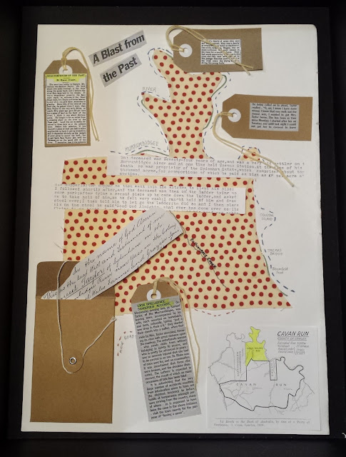
Annotated map of Taemas This blog post will be a bit waffly because I am fast running out of time to think clearly and make sensible well considered posts.  Please forgive me.   Recently, for another University of Tasmania course called Place, Image, Object  we had to make an annotated map of a place that was significant to us or our family history, bringing together subjective and objective elements. What an agonizing but fruitful exercise it was.  I chose to do a map showing some of my ancestor's land near Yass and Canberra where I grew up.  My ancestor was Samuel Taylor. Here is my reflection on the task. I created several annotated maps in the process of creating the final annotated map for my ancestor, Samuel Taylor.  At first I wanted to show how place names can be duplicated in different areas.  For example.  George Willmore originally called Arana Hills, the suburb where I work in Queensland, after Camden Park – a place familia...

A is for ADM

Image
Chart of the Pacific showing French, German, Spanish & British occupancies.This map of the Pacific Islands shows French, British, German and Spanish occupancy in the Pacific. It was lithographed from a British Admiralty map of 1884. French territories are shown in blue. From Archives New Zealand on  Flickr  A is for ADM. Welcome to the first of my posts for the A-Z Challenge.  I am a family historian/librarian and my chosen theme for this month is all things Navy!   My goal is to feature posts on everything from ships to archival records, from job descriptions to places associated with the Navy.   I am based in Australia but my heritage lies in the UK so when I say Navy, I will be referring to the Royal Navy and the Royal Australian Navy to a large extent. Please forgive my parochialism/ethnocentricity.   ADM is an acronym or abbreviation for  Admiralty  used with The National Archives series of records. Records within t...

14th Australasian Congress on Genealogy and Heraldry - Reflections and Wrap Up

Image
Standing Figure by Ante Dabro at University House I promised to write a wrap-up post of my experience of Sunday's talks at the 14th Australasian Congress on Genealogy and Heraldry  in Canberra so here goes.. SUNDAY 29 MARCH Keynote Address: Meeting people at war: writing war on the home front - Michael McKernan Michael McKernan - photo courtesy of  Allen and Unwin I was really interested in listening to this talk mostly because I've been busting a gut (to use an impolite phrase) creating PowerPoint presentations for our library service to commemorate the lives of the soldiers from the region who enlisted in the Great War.  The PowerPoints are just part of the displays we have in each library and they include display cases filled with artefacts from local RSLs and museums and some A2 sized themed posters. Foyer Caboolture Library with WWI Displays WWI Display Caboolture Library Burpengary Library posters These photos give you a ...

Follow Friday

Image
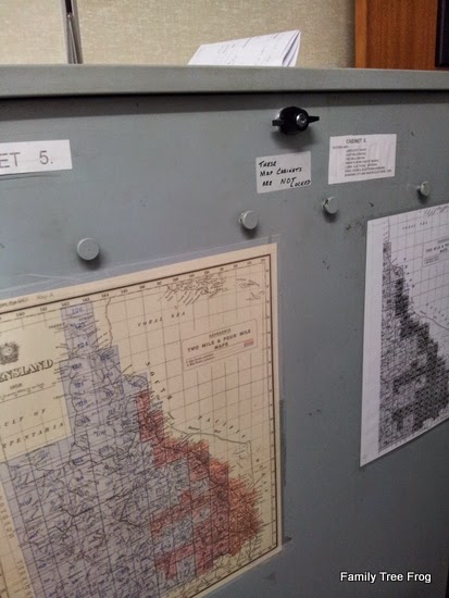
What a huge week it has been genealogy wise for me.  Lots of things to learn and discover. Saturday morning was spent at my Society taking part in a Library Assistant's workshop.  These are held a couple of times a year and are designed to help you be a better library assistant.  One of the mini talks/presentations was about the Map Room.  This is always a vastly underused resource at the QFHS Library.  I'm always amused at how I always learn something despite going into the library at least once a month on duty and having been a member for probably about thirty years now. We all practised getting maps out of the cabinets.  The cabinets can be a bit intimidating to newbies.  Once the door is open, I think people are petrified that all the maps are going to fall out if the door doesn't catch.  I've got the hang of it now but was amused to notice for the first time the little "buttons" or knobs on the outside of the map cabinets to hang...

150 Years Ago

Image
From Randy Seaver at Genea-Musings. .. Your mission, should you decide to accept it (cue the Mission Impossible! music) is to: 1)  Determine where your ancestral families were on 1 September 1863 - 150 years ago. 2)  List your ancestors, their family members, their birth and death years, and their residence location (as close as possible).  Do you have a photograph of their residence from about that time, and does the residence still exist? 3)  Tell us all about it in your own blog post, in a comment to this post, or in a Facebook Status or Google+ Stream post. The Conners Edward Conner (1829 - 1903) - an engineer in the Royal Navy and his wife Rebecca (1830-?) would have been living in 4 Kilminston Street Portsea, Hampshire, England with their children Edward G (7 years old) and Clara Rebecca (5 years old) and Walter (2 years old) as per the 1861 Census.   I suspect that Kilminston Street is now called Kilmiston Close as per the ma...